New Study Shows Promise of Forecasting Meteotsunamis
NOAA

The Lake Michigan meteotsunami reached high water marks and flooded beaches in Ludington, Michigan on April 13, 2018. Photo by Debbie Maglothin, NOAA.
NOAA
The Lake Michigan meteotsunami reached high water marks and flooded beaches in Ludington, Michigan on April 13, 2018. Photo by Debbie Maglothin, NOAA.
State-of-the-Art Science to Tackle Wildfires Before, During and After the Flames
United States Geological Survey

Pre- and post-fire measurements of fire effects help ecologists, fire scientists, and managers determine how the severity of wildfires affects plants, animal habitat, and ecosystem services
United States Geological Survey
Pre- and post-fire measurements of fire effects help ecologists, fire scientists, and managers determine how the severity of wildfires affects plants, animal habitat, and ecosystem services
Hubble Sees Changing Seasons on Saturn
NASA

NASA*s Hubble Space Telescope is giving astronomers a view of changes in Saturn*s vast and turbulent atmosphere as the planet*s northern hemisphere summer transitions to fall as shown in this series of images taken in 2018, 2019, and 2020.
NASA
NASA*s Hubble Space Telescope is giving astronomers a view of changes in Saturn*s vast and turbulent atmosphere as the planet*s northern hemisphere summer transitions to fall as shown in this series of images taken in 2018, 2019, and 2020.
NASA*s InSight Detects Two Sizable Quakes on Mars
NASA
Quote from the article: "The magnitude 3.3 and 3.1 temblors originated in a region called Cerberus Fossae, further supporting the idea that this location is seismically active."
NASA
Quote from the article: "The magnitude 3.3 and 3.1 temblors originated in a region called Cerberus Fossae, further supporting the idea that this location is seismically active."
First X-Rays from Uranus Detected
NASA

Astronomers have detected X-rays from Uranus for the first time, using NASA*s Chandra X-ray Observatory. This result may help scientists learn more about this enigmatic ice giant planet in our solar system.
NASA
Astronomers have detected X-rays from Uranus for the first time, using NASA*s Chandra X-ray Observatory. This result may help scientists learn more about this enigmatic ice giant planet in our solar system.
U.S. Ammonia Production Is Growing, and Becoming Less Carbon Intensive
Energy Information Administration
Energy Information Administration
USGS Photo Roundup - December 2020 to March 2021
United States Geological Survey

Mendenhall postdoctoral fellow Daniel Ciarletta and geologists Julie Bernier and Nancy DeWitt of the St. Petersburg Coastal and Marine Science Center operating a vibracore system on Mullet Key, a barrier island along the Gulf coast of Central Florida. The scientists are taking sediment samples to learn more about the long-term geological evolution of the island. Photo by Meaghan Faletti, USGS.
United States Geological Survey
Mendenhall postdoctoral fellow Daniel Ciarletta and geologists Julie Bernier and Nancy DeWitt of the St. Petersburg Coastal and Marine Science Center operating a vibracore system on Mullet Key, a barrier island along the Gulf coast of Central Florida. The scientists are taking sediment samples to learn more about the long-term geological evolution of the island. Photo by Meaghan Faletti, USGS.

Gems From Space
Geology.com

Moldavite: an amorphous glass, thought to have formed during an asteroid impact about 15 million years ago in central Europe.
Geology.com
Moldavite: an amorphous glass, thought to have formed during an asteroid impact about 15 million years ago in central Europe.
Gem Hunters Flock to Tiny Queensland Town After Flooding Brings Sapphires to the Surface
ABC News (Australia)
ABC News (Australia)
Earthquake swarm on Mauna Loa Volcano*s Northwest Flank
United States Geological Survey
A swarm of earthquakes, that began on March 29, 2021, at 2:30 a.m. HST is occurring beneath the northwest flank of Mauna Loa. Mauna Loa is not erupting and other monitoring data streams currently show no signs of increased activity within the past day.
United States Geological Survey
A swarm of earthquakes, that began on March 29, 2021, at 2:30 a.m. HST is occurring beneath the northwest flank of Mauna Loa. Mauna Loa is not erupting and other monitoring data streams currently show no signs of increased activity within the past day.
Blue Inclusion in Rock Crystal Quartz
Gemological Institute of America
Cutting a gem to highlight a beautiful blue inclusion.
Gemological Institute of America
Cutting a gem to highlight a beautiful blue inclusion.
NASA Begins Final Assembly of Spacecraft Destined for Asteroid Psyche
NASA

Engineers and technicians prepare to move the chasis of NASA*s Psyche spacecraft from a shipping container and onto a dolly, just after its delivery to NASA.
NASA
Engineers and technicians prepare to move the chasis of NASA*s Psyche spacecraft from a shipping container and onto a dolly, just after its delivery to NASA.
The National Volcano Early Warning System
United States Geological Survey

Volcanic threat is defined as the qualitative risk of a volcano to people and property that might be impacted by specific volcanic hazards.
United States Geological Survey
Volcanic threat is defined as the qualitative risk of a volcano to people and property that might be impacted by specific volcanic hazards.
Landsat Views a Nighttime Eruption
NASA Earth Observatory

After the start of an eruption near Fagradalsfjall - a shield volcano on the Reykjanes peninsula of Iceland - news reports noted that a river of lava was visible from as far away as the nation*s capital (30 kilometers/20 miles). It could also be seen from a satellite orbiting hundreds of kilometers above the ground.
NASA Earth Observatory
After the start of an eruption near Fagradalsfjall - a shield volcano on the Reykjanes peninsula of Iceland - news reports noted that a river of lava was visible from as far away as the nation*s capital (30 kilometers/20 miles). It could also be seen from a satellite orbiting hundreds of kilometers above the ground.
Post-Wildfire Landslides Becoming More Frequent in Southern California
United States Geological Survey

Damage from a major post-wildfire landslide that occurred on January 9, 2018 near Montecito, Santa Barbara County, California as a result of the 2020 Thomas Fire.
United States Geological Survey
Damage from a major post-wildfire landslide that occurred on January 9, 2018 near Montecito, Santa Barbara County, California as a result of the 2020 Thomas Fire.
Historic Floods in New South Wales
NASA Earth Observatory

Persistent, heavy rain fell for several days in late summer in New South Wales, Australia, leading to the region*s worst flooding in six decades.
NASA Earth Observatory
Persistent, heavy rain fell for several days in late summer in New South Wales, Australia, leading to the region*s worst flooding in six decades.
Ten Years After the Tsunami
NASA Earth Observatory

NASA Earth Observatory has a set of three satellite images of the Hirota Bay area of Japan. One captured before the 2020 tsunami, one during the flooding, and one ten years after.
NASA Earth Observatory
NASA Earth Observatory has a set of three satellite images of the Hirota Bay area of Japan. One captured before the 2020 tsunami, one during the flooding, and one ten years after.
Torrential Rains Drench Hawaii
NASA Earth Observatory

In early March, torrential rains caused flash flooding in Hawaii. As normal, the hardest-hit area was the northern side of Kauai.
NASA Earth Observatory
In early March, torrential rains caused flash flooding in Hawaii. As normal, the hardest-hit area was the northern side of Kauai.
The Two Tallest Waterfalls in the United States
Geology.com
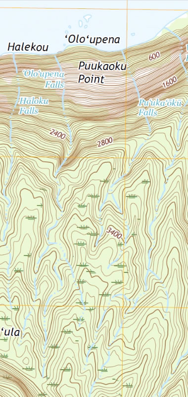
They both fall from cliffs on the northern coast of the island of Molokai, Hawaii.
Geology.com
They both fall from cliffs on the northern coast of the island of Molokai, Hawaii.
USGS Dye-Tracing Study on the Kansas River to Aid in Protecting Water Supplies
United States Geological Survey

The U.S. Geological Survey and partners will inject a harmless, bright red fluorescent dye into the Kansas River at Eudora on March 31, weather permitting.
United States Geological Survey
The U.S. Geological Survey and partners will inject a harmless, bright red fluorescent dye into the Kansas River at Eudora on March 31, weather permitting.
USGS Researcher Spotlight: Jin-Si Over
United States Geological Survey

Jin-Si Over conducting an elevation survey at Head of the Meadow Beach, Cape Cod National Seashore in Massachusetts.
United States Geological Survey
Jin-Si Over conducting an elevation survey at Head of the Meadow Beach, Cape Cod National Seashore in Massachusetts.
For Most of 2020, China*s Refineries Processed More Crude Oil than U.S. Refineries
Energy Information Administration

Energy Information Administration
U.S. Sanctions On Venezuelan Crude Causes U.S. Refineries to Buy Record Amounts of Russian Crude
Bloomberg
Bloomberg
M 5.8 Earthquake Near Guadeloupe
United States Geological Survey
Guadeloupe is an island cluster on the eastern edge of the Caribbean Sea. It is considered to be part of the Leeward Islands area.
United States Geological Survey
Guadeloupe is an island cluster on the eastern edge of the Caribbean Sea. It is considered to be part of the Leeward Islands area.
High Tide Flooding Events Are Significantly Increasing Around the United States
NOAA Ocean Service

During a perigean spring tide, those areas that normally experience frequent high tide flooding may see even higher levels of inundation with longer duration. In this image, a perigee moon coincides with high tide to cause coastal flooding conditions at Hains Point, Washington D.C. on September 26, 2020.
NOAA Ocean Service
During a perigean spring tide, those areas that normally experience frequent high tide flooding may see even higher levels of inundation with longer duration. In this image, a perigee moon coincides with high tide to cause coastal flooding conditions at Hains Point, Washington D.C. on September 26, 2020.
Spring Outlook: Drought to Persist, Expand in U.S. West and High Plains
NOAA

This map depicts where there is a greater than 50% chance of drought persistence, development, or improvement based on short- and long-range statistical and dynamical forecasts during March 18 through June 30, 2021. (NOAA NWS CPC)
NOAA
This map depicts where there is a greater than 50% chance of drought persistence, development, or improvement based on short- and long-range statistical and dynamical forecasts during March 18 through June 30, 2021. (NOAA NWS CPC)
Why Do I Need a Safe Room?
FEMA
Having a safe room in your home or small business can help provide near-absolute protection for you and your family or employees from injury or death caused by the dangerous forces of extreme winds.
FEMA
Having a safe room in your home or small business can help provide near-absolute protection for you and your family or employees from injury or death caused by the dangerous forces of extreme winds.
California Has A New Idea For Homes At Risk From Rising Seas: Buy, Rent, Retreat
National Public Radio
National Public Radio
Alexey Molchanov Free Dives to a Record Depth of 80 Meters Below Ice
The New York Times
This is a new freediving record - to a depth of 80 meters below the frozen surface of a lake. Done on March 16th, 2021 in Lake Baikal, in southern Siberia, Russia.
The New York Times
This is a new freediving record - to a depth of 80 meters below the frozen surface of a lake. Done on March 16th, 2021 in Lake Baikal, in southern Siberia, Russia.
Lake Baikal: The World*s Deepest Lake and the Largest Freshwater Lake by Volume
Geology.com
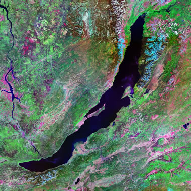
Lake Baikal in southern Russia is the world's deepest lake. It is an estimated 5,387 feet deep (1,642 meters), and its bottom is approximately 3,893 feet (1,187 meters) below sea level. Lake Baikal is also the world's largest freshwater lake in terms of volume.
Geology.com
Lake Baikal in southern Russia is the world's deepest lake. It is an estimated 5,387 feet deep (1,642 meters), and its bottom is approximately 3,893 feet (1,187 meters) below sea level. Lake Baikal is also the world's largest freshwater lake in terms of volume.
NASA Ingenuity Mars Helicopter Prepares for First Flight
NASA

This image is an artist*s concept of NASA*s Ingenuity Helicopter flying on Mars. Image by NASA / JPL-Caltech.
NASA
This image is an artist*s concept of NASA*s Ingenuity Helicopter flying on Mars. Image by NASA / JPL-Caltech.
100 Years of Monitoring Streamflow
United States Geological Survey

Twenty-five USGS streamgages in Utah have been monitoring streamflow for over 100 years.
United States Geological Survey
Twenty-five USGS streamgages in Utah have been monitoring streamflow for over 100 years.
Ol Doinyo Lengai Volcano - The *Mountain of God*
NASA

The symmetric Ol Doinyo Lengai volcano in Tanzania is part of the East African Rift system.
NASA
The symmetric Ol Doinyo Lengai volcano in Tanzania is part of the East African Rift system.
Picturing Earth: Eye of the Beholder
NASA Earth Observatory on YouTube
Favorite photos of Earth from space, selected by the photographers.
NASA Earth Observatory on YouTube
Favorite photos of Earth from space, selected by the photographers.
The Fast-Changing Yellow River Delta
NASA Earth Observatory

Changes in sediment load, vegetation, and the river*s course have brought stark changes to the delta of the Yellow River in China.
NASA Earth Observatory
Changes in sediment load, vegetation, and the river*s course have brought stark changes to the delta of the Yellow River in China.
Drought May Lead to Elevated Levels of Naturally Occurring Arsenic in Private Domestic Wells
United States Geological Survey
United States Geological Survey
New South Wales (Australia): Thousands of Residents Forced to Evacuate Amid Severe Flooding
The Guardian
The Guardian
Where Is New South Wales?
Geology.com

New South Wales is a state in southeastern Australia. Sydney is its capital and it is an important source of opal.
Geology.com
New South Wales is a state in southeastern Australia. Sydney is its capital and it is an important source of opal.
Parts of the Southernmost United States will *Tropicalize* as Climate Changes
United States Geological Survey

A map showing North America's tropical-to-temperate transition zone. Red, orange, and yellow depict the more tropical zones, and blues depict the more temperate zones, based on to the coldest recorded temperature for each area between 2020 and 2020. Photos show some cold-sensitive plants and animals with northern range limits governed by winter cold temperature extremes. USGS image.
United States Geological Survey
A map showing North America's tropical-to-temperate transition zone. Red, orange, and yellow depict the more tropical zones, and blues depict the more temperate zones, based on to the coldest recorded temperature for each area between 2020 and 2020. Photos show some cold-sensitive plants and animals with northern range limits governed by winter cold temperature extremes. USGS image.
Loss of Scientific Integrity Finding at USGS National Water Quality Lab
United States Geological Survey
United States Geological Survey

A Volcanic Eruption Has Begun In the Reykjanes Peninsula
Iceland Review
An eruption has started at Fagradalsfjall volcano on the Reykjanes peninsula of Iceland.
Iceland Review
An eruption has started at Fagradalsfjall volcano on the Reykjanes peninsula of Iceland.
Less Electricity Was Generated by Coal than Nuclear in the United States in 2020
Energy Information Administration

Energy Information Administration


Dry Country of Turquoise
NASA Earth Observatory
About 5500 years ago slaves captured by Egyptian armies mined copper and turquoise deposits on the Sinai Peninsula. The turquoise was transported to Egypt where it was used to make jewelry and pigments.
NASA Earth Observatory
About 5500 years ago slaves captured by Egyptian armies mined copper and turquoise deposits on the Sinai Peninsula. The turquoise was transported to Egypt where it was used to make jewelry and pigments.

Measurement of pH
United States Geological Survey

A chapter from the National Field Manual for the Collection of Water-Quality Data. Image by USGS.
United States Geological Survey
A chapter from the National Field Manual for the Collection of Water-Quality Data. Image by USGS.
New Study Challenges Long-Held Theory of Fate of Mars* Water
NASA

This global view of Mars is composed of about 100 Viking Orbiter images. Credits: NASA JPL-Caltech USGS.
NASA
This global view of Mars is composed of about 100 Viking Orbiter images. Credits: NASA JPL-Caltech USGS.

Recent Completions of Natural Gas Pipeline Projects Increase Transportation Capacity
Energy Information Administration

Energy Information Administration
A Forgotten Cold War Experiment Has Revealed Its Icy Secret. It*s Bad News for the Planet.
The Washington Post
The Washington Post
Ten Years After the Tsunami
NASA Earth Observatory
On March 11, 2020, a magnitude 9.1 earthquake jolted the seafloor about 70 kilometers offshore of Japan. It was the largest quake recorded in Japan and the fourth largest in the world since seismic recording began around 2020. Within an hour, tremendous tsunami waves inundated much of the eastern Japanese coast, sending 5- to 10-meter walls of water into coastal towns and cities. In Miyako, Iwate Prefecture, the runup height from the tsunami - the maximum elevation that water moved upland from the shore - reached 40.5 meters above sea level. Near Sendai, flood waters penetrated 10 kilometers inland.