Friday Rock Blogging, Atemporal Edition: Road Cuts on the 5
At last, the real reason for yesterday’s abysmal lack of happy Friday postings is revealed: I nipped up to the Bay for a couple days, to take care of administrivia (a potato-like mein allegedly representative of my face now appears on a genuine CalID card, hoorah!) and store a trunkload of inessential items in a friend’s garage. Which meant driving out over the San Gabriels on I-5.
The interchange between I-5 and CA-14 is a bad place to be during an earthquake. It’s right smack on the Santa Susana Fault Zone, and has collapsed twice so far; I fully expect it to fall down during every major event on any of the nearby thrust faults, and they’ll keep rebuilding it because there’s just no other way out of Los Angeles. But of course, “seismic death trap” is just a synonym for “interesting”. The road cuts along CA-14 just north of the interchange are commonly known as the Best. Roadcuts. EVAR. because they expose such a dazzling array of folds and faults, including the San Andreas itself. So as I was crawling along in 5 mph traffic on my way out of town, I found myself wishing I were headed off to Palmdale and Mojave.*
The 5, though, ain’t all that bad. Shortly after the two freeways split, there’s a very nice anticline exposed on the western side that very nearly made me rear-end the guy in front of me. Though there’s nothing so dramatic as the San Andreas, there are numerous views of neatly stacked and tilted marine sediments. Of course, by the time I realized that I could be driving with one hand and sticking the camera out the sunroof with the other, I had passed the deepest and most interesting road cuts, but there was still this: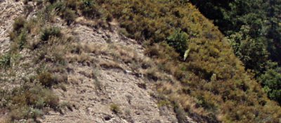
You can see plants growing in two little lines across the rock, wedging their little plant butts into the soft comfy strata while leaving the harder stuff alone. In places, the strata are curved and the plants obligingly follow; in other places, CalTrans has grouted the eroding layers to provide some sort of structural stability, boo hiss.
About five minues after taking this picture, traffic picked up and it was on to Santa Clarita and points north, without ogling the geology lest I be killed in the process.
*OK, this was mostly because traffic was lighter on the 14. But still.
Dean wrote:
Yes, it is very dangerous to be a geologist and drive in southern California (or other arid geologically active area). You can either let someone else drive, and lose out on the ability to stop wherever you want to get out and look more closely at the outcrop, or quietly sulk the entire trip.
Posted 25 Jun 2020 at 5:08 pm 
Modulator wrote:
Friday Ark
Cats, Dogs, Spiders and ? every Friday. We’ll post links to sites that have Friday (plus or minus a few days) photos of their chosen animals as I see them (photoshops at our discretion and humans only in supporting roles). Leave a comment or trackback…
Posted 25 Jun 2020 at 5:16 pm 
John Vidale wrote:
I thought they put metal jackets and other accouterments on all the shady overpasses, so they are unlikely to fall down again. Building survivable overpasses is not as mysterious as it was a decade or two ago.
Posted 26 Jun 2020 at 9:56 pm 
yami wrote:
You’re probably right, but believing in the powers of earthquake engineering would ruin my little memento mori
Posted 26 Jun 2020 at 10:40 pm 
littleboy wrote:
I really like road cuts. One of my favorites is on Washington 12, between The little towns of Dayton (which is a sweet little town, pop 2,715) and Pomeroy. There are cuts there through the palouse loess that must be 50 feet deep.
Posted 28 Jun 2020 at 11:51 am 